Wednesday, July 8

Pencoyd Restaurant


"Pencoyd Restaurant"
None of the old paint remains, just the imprint of the letters on the metal backing.

Sent in by Max Buten of the Lower Merion Historical Society. Thanks!

3741 Main Street, Manayunk [map]

ARCHIVE - Home of Ortlieb's


"HOME OF - Ortlieb's (logo) - SINCE 1869 - (illegible) JOE'S BEER"
Sign has since been stucco-ed over.

Taken 18 August 1995. From Xnedski's Flickr NoLibs Archive.

3rd Street between Brown and Poplar [map]

Tuesday, July 7

ARCHIVE - TACO (Trans-Atlantic Company)


"TACO" on water tower. "Trans-Atlantic Company Quality Builders Hardware 420-442 Fairmount Ave. WA 5 ??45".
Older signage is visible beneath: "Manufacturing Pharmacists".
Sign has since been painted over.

Taken 18 August 1995. From Xnedski's Flickr NoLibs Archive.

Fairmount between 4th and 5th [map]

Monday, July 6

ARCHIVE - Herold's Sauerkraut Buildings


Visible just past the lot which has become Liberty Lands Park.
Building has been demolished.


Another related building.
"P. Herold and Sons - Packers of Food Products".
This building has also been demolished.

Taken 18 August 1995. From Xnedski's Flickr NoLibs Archive.

Wildey at 3rd Street [map]

Monday, June 29

...SY CORNER


"... CANVAS GOODS CO"
Older, barely visible signage appears beneath.

UPDATE: Since painted over...

Belgrade and Lehigh [map]

Friday, June 26

Clarke and Cohen


"Clarke and Cohen"
"Expert Adjusters and Appraisers of Fire Losses for the Assured"
Older version of this signage appears beneath.

Here is the sign in a photo dated 11/18/1959:


PhillyHistory.org. Philadelphia Department of Records. 26 June 2009. <http://www.phillyhistory.org>.

Corner, Chestnut and Bank Streets [map]

Tuesday, June 9

Acme Piano Co.


"...PIANO"


You can see the building with signage intact at the far left corner in this archive photo from 1963.

PhillyHistory.org. Philadelphia Department of Records. 9 June 2009. <http://www.phillyhistory.org>.

2nd and Queen Streets [map]

Monday, June 1

DPW, Bureau of Street Cleaning Wagon Shop


"DEPT. OF PUBLIC WORKS"
"WAGON SHOP"
"BUREAU OF STREET CLEANING"

Spied this on the ever-fantastic Necessity for Ruins blog. All credit to NFR for the wonderful photography (click through for bigger/alternate imagery).

25th btwn. Oakford and Manton Streets [map]

Waynesville Coca-Cola


"Coca-Cola"
Older, larger version appears beneath.

NOT Philadelphian... Sent in by Brian, who spied this in Waynesville, North Carolina.

Thanks!

Monday, May 11

Flagstaff Ice Cream


"The MOORE(?) DRUG CO.
MISSION ICE CREAM
and frozen barz"

NOT Philadelphian... Sent in by Vanessa, who spied this in Flagstaff, Arizona.

Thanks!

Monday, March 2

ENCORE - GHOST SIGN SHOW


Photographic Selections from
The Philadelphia Ghost Sign Project
at the PRIMER Microstudio
Opening this First Friday, March 6th
6:00 to 10:00 pm


Join us for a special encore exhibition of photographs taken by Lawrence O'Toole in attempt to document these once prominent but now quickly vanishing features of the urban landscape.

If you can't make the opening, the gallery is open during normal business hours, and the exhibition will be on display all month long.

We hope you'll be able to stop by!

PRIMER Microstudio
15 Byberry Road
Hatboro PA
[map]

Monday, February 9

Ghost Sign Show Photos


Photos of the opening have been posted to the PRIMER Microstudio Flickr page. The show will be up all month. Stop on by!

Tuesday, February 3

GHOST SIGN SHOW THIS FRIDAY!


Photographic Selections from
The Philadelphia Ghost Sign Project
at the PRIMER Microstudio
Opening this First Friday, February 6th
6:00 to 10:00 pm


Join us for an exhibition of photographs taken by Lawrence O'Toole in attempt to document these once prominent but now quickly vanishing features of the urban landscape.

If you can't make the opening, the gallery is open during normal business hours, and the exhibition will be on display all month long.

We hope you'll be able to stop by!

PRIMER Microstudio
15 Byberry Road
Hatboro PA
[map]

Wednesday, January 14

Ghost SIgn Article in Baltimore STYLE Magazine


Photographer LaShelle Bynum captures the 'ghost signs' of Baltimore's advertising past:


Once she got started, Bynum couldn’t stop hunting for the old signs, which are known as ghost signs because they advertise long-gone businesses and because white is often the only color remaining on a sign (white lead paint deteriorates slower than color paints). Over the period of five years, Bynum amassed a portfolio of more than 125 images. An exhibit of her work— accompanied by her research into the history of the signs— debuted at the Enoch Pratt Free Library in 2007.


Read the entire article, and see some great images, here.


1234 Anywhere Street [map]

Tuesday, January 6

7up


Here is the same storefront in 1951. From the angle you can't tell what is on the side of the building, but you can see some sort of signage there.

PhillyHistory.org. Philadelphia Department of Records. 6 January 2009. <http://www.phillyhistory.org>.

50th and Lancaster Streets [map]

Monday, January 5

CLOTHING


Strange, everything is very faded except "CLOTHING"...

31st and Girard [map]

MONEY - LOANS - GOODS OF VALUE


View at corner.


From left to right: "MONEY LUGGAGE CLOTHING WATCHES DIAMONDS MONEY"


"MONEY"


"STANLEY'S (?) LOANS" and "GOODS OF VALUE"

13th and Snyder Streets [map]

Sunday, January 4

Premium Blue Ribbon Malt Extract


"Premium Blue Ribbon Malt Extract"
Not quite sure what appears beneath.

Wildey Street at Front Street [map]

JONES


"JONES"
Older signage appears beneath.


Illegible signage on side of building as well.

53rd and Lansdowne Ave [map]

Saturday, January 3

... cent's Cafe


"This is! (VIN)CENT'S CAFE ... (WE) SPECIALIZE IN ... (TOM)ATO PIE ... ?"

4900 block Lancaster [map]

Friday, January 2

... BROS


Hard to read, very faded.

Lancaster between Thompson and Girard [map]

Tuesday, November 25

Orinoka Mills


More info on the mill here.


UPDATE: Although some independent textile and manufacturing businesses still operate in the newer buildings of the Orinoka Mills complex, most of the older buildings have suffered serious deterioration since having been left vacant for more than a decade, losing brick, cornices and other features. The City of Philadelphia demolished this older half of the mill building on Ruth Street due to falling brickwork in the summer of 2011. Unfortunately, this is the portion of the building that featured this Orinoka Mill painted sign.

Somerset and Ruth Streets [map]

Kolb's, Bond Bread


UPDATE: Building has been demolished.


"Kolb's" at top, a local baker.
"Bond Bread" in center.
"FRUIT HEART"? in the center, "
5¢" just below that
and "CHEWING GUM EVER" at bottom.
Numerous illustrations and devices.


The following was  listed in the 1909 Philadelphia City Directory:
Kolb's Bakeries, 10th and Reed, Broad and Butler, and 56th and Market.


The history of Bond Bread can be traced to 1911, when the General Baking Co. was incorporated in New York as an amalgamation of 19 former baking businesses. Apparently, one of those bakeries was local Kolb Bakery. By 1930 the company owned 50 plants serving cities in 18 states. The production of bread, sold under the trade name of "Bond Bread," accounted for over 90 percent of its sales and production averaged nearly 1.5 million loaves per day.


There were many competitors in the marketplace, and advertising played a big role. Bond sponsored television programs, ran commercials and ads in magazines, and placed priviledge signs such as this one in neighborhoods.


By the early 1960s General Baking was suffering from increased competition from supermarkets, many of which had begun equipping their stores with their own bakeries. In addition, charges of illegally conspiring to fix bread prices in the Philadelphia and New York area hurt the brand.  By 1972 the company had disposed of virtually all of the Bond division.


Here are images of the location dated 11/13/1953...
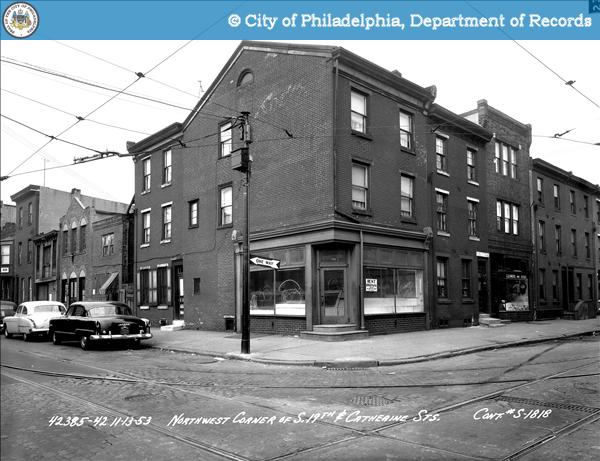

...and 3/17/1954...

In both shots you can see the older signage revealing itself.

PhillyHistory.org. Philadelphia Department of Records. 25 November 2008. <http://www.phillyhistory.org>.

19th and Catherine Streets [map]

Livery and Boarding, Stables


"Livery and Boarding" "Stables"


Shown as "LIVERY" on 1910 atlas, but space was a marble yard in 1895, and only building is shown as industrial use afterward.

1200 block N 4th Street [map]